Frequent Border Tensions in South and Southeast Asian Countries and Its Complex Border Security Management
![]()
Dr. Sarder Ali Haider
A border is a physical or political line that separates geographic areas[1]. These are the geographic boundaries of political entities or legal jurisdictions, such as governments, sovereign states, federated states, and other subnational entities. Borders are established through agreements between political or social entities that control those areas; the creation of these agreements is called boundary delimitation. Some borders such as a state’s internal administrative border, or inter-state borders within the Schengen Area are often open and completely unguarded. Other borders are partially or fully controlled, and may be crossed legally only at designated border checkpoints and border zones may be controlled. Open borders are to allow for the cross-border flow of legitimate trade and commerce, and secure in the sense that the national security interests of states are protected. There are different categories of border demarcation in the world. Some are naturally demarcated by various features, some are artificially fenced and in some cases, there is no necessity of creating any obstructions. The following statistics highlight the top length land borders amongst all the countries in the world[2]:
- Canada-USA : 8,893 km
- Russia-Kazakhstan : 6,846 km
- Argentina-Chile : 5,300 km
- Mongolia-China : 4,677 km
- India-Bangladesh : 4,096 km
- Russia-China : 3,645 km
- Russia-Mongolia : 3,543 km
- Brazil-Bolivia : 3,400 km
- China-India : 3,380 km
- USA-Mexico : 3,141 km
USA – Canada border is the longest international border in the world between two countries. It is 8,891 kilometers long; of which 2,475 kilometers is Canada’s border with Alaska.

The global Border and Security Management program aims to protect the borders from the illegal movement of weapons, drugs, contraband, and people, while promoting lawful trade and travel, is essential to internal security, economic prosperity, and national sovereignty. Ensuring effective border security and management is essential for preventing and countering the flow of suspected terrorists and foreign terrorist fighters across land, air, and maritime borders. Border security and management is also imperative to curb the illicit cross-border movement of arms, ammunition, explosives, hazardous materials, goods and cargo that may be used for terrorism purposes.
The border security becomes priority issue considering the presence of natural features and the bi-lateral relations between the two countries. The border management of Israel is considered to be most secured in the world[3]. Possibly, Israel had to provide more priority in the border security due to its tension with the neighboring countries. In the context of South and Southeast Asian countries, there are tensions almost in every place. India, Pakistan and China are basically the main stake holders of these tensions. However, the neighboring countries of those nations also remain concern for various border related skirmishes.
Israel’s expertise in border security is world-renowned. Israeli companies offer sophisticated electronic and virtual fences, with video motion detection capabilities; electro-optical-based surveillance; autonomous unmanned aerial, ground and maritime patrol vehicles; advanced tracking and screening of people, vehicles and cargo; advanced thermal imagers; long-range radars; as well as underground sensors to detect tunnels[4].
For strong deterrence capabilities, defensible borders are crucial. The concept of defensible borders, as described by former Israeli national security adviser Uzi Dayan, is based on the three key components: “strategic depth, the ability to defend yourself from an attack from the outside and fighting terrorism effectively.” [5]

In the recent years India is utilizing Israeli expertise in their border management[6]. The existing security infrastructures to deal with the border security challenges are being revived. The countries which are sharing border with India might be in a close watch on the recent border management of India. Bangladesh shares the longest border with India among the neighbors. The counties sharing border with India and the security forces which are deployed along the border are as follows:
| Land Border Countries | Length | Security Forces |
| Bangladesh | 4096 km | Border Security Force |
| Bhutan | 699 km | Sashastro Seema Bal
(one of India’s Central Armed Police Forces) |
| China | 3488 km | Indo-Tibetan Border Police[7]
(One of the five Central Armed Police Forces of India, raised on 24 October 1962, under the CRPF Act, in the wake of the Sino-Indian War. The ITBP was intended for deployment along India’s border with Tibet) and Special Frontier Force[8] (The Special Frontier Force is a paramilitary special force of India created on 14 November 1962. Its main goal originally was to conduct covert operations behind Chinese lines in the event of another Sino-Indian War) |
| Myanmar | 1643 km | Assam Rifles
(The oldest paramilitary force in India) and Indian Army |
| Nepal | 1751 km | Sashastro Seema Bal |
| Pakistan | 3323 km | Border Security Force |
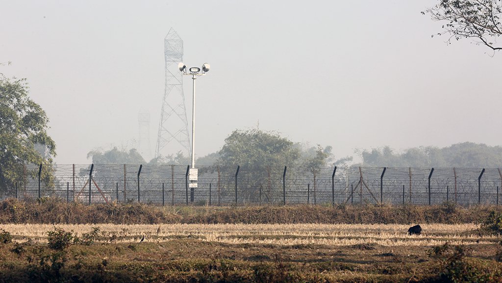
In January 2016, the Indian government approved an elaborate five-layer plan to stop infiltration on the India-Pakistan border. There is a plan to deploy close-circuit television cameras, thermal imagers and night vision devices, BFSRs, underground monitoring sensors, and laser barriers along the border. The ‘rickety’ barbed wires along the Pakistan and Bangladesh border are being replaced with meshed fence made of steel. BSF has been tasked to ensure that the fence is installed in a time-bound manner. The estimated cost for this improved fencing is about 20 million rupees per kilometer. The Central Public Works Department (CPWD) is implementing the project with an assistance of an Irish construction firm AON Fencing & Gates[9]. The existing fencing became very old in most of the places. It could be easily cut with cutters and other heavy tools which raised the rate of illegal infiltration.

The new anti-cut fencing will be more effective. Currently a pilot project has been sanctioned at a cost of fifteen million rupees at Lathitila in Assam’s Silchar district. The uncut single-row fence, with loops of concertina wires on top, is being erected at a 60km border stretch near Amritsar in Punjab also.

In 2015, the Indian government started implementing the initial version of the comprehensive integrated border management system (CIBMS) project. One of the important components of the CIBMS is the use of satellite imagery, which helps security forces to analyze the terrain and fortifications along the border. It also helps in planning operations and in infrastructure development. The difficult terrain areas and riverine tracts which could not be fenced are possible to cover by utilizing CIBMS. This system is capable of creating laser or virtual walls. These type of virtual walls will be useful for riverine patches and mountainous terrains which otherwise cannot be fenced through traditional mechanisms. India is planning to have a patrol-free, multi-layered smart fence along its borders with Pakistan and Bangladesh.
There is also a plan to install underwater and underground sensor systems to check infiltration. The technology to be integrated includes automated guns, radars with 360-degree detection capability, and versatile airborne micro-aerostat balloons fitted with high-quality surveillance cameras along the border.
In 2016, the Indian government sanctioned 2,030.44 km of floodlights along the international border in the states of Jammu and Kashmir, Punjab, Rajasthan, and Gujarat, and decided to deploy laser fencing at the 45 vulnerable spots along the Indo-Pak border in Punjab and the Jammu and Kashmir region.

There is another concern while doing the Border Security Management that is Drone. Drones are often used by both India and Pakistan for conducting surveillance across the border.

In the recent past, terrorists and miscreants have started using load-carrying drones that carry arms, ammunition and drugs[10]. All the border security forces need to be intrusive and technically proficient in detecting and neutralizing this type of miscreant exertion in the bordering areas.
The boundary demarcation line between India and Pakistan was designated as per the Radcliffe Line during the partition of India in 1947[11]. Afterwards, since the independence in 1971, Bangladesh and India are sharing approximately 4096 km international border. At present there are fences in the maximum places of Bangladesh- India border. Out of which, there is also 61 km long smart fencing along this border in Assam’s Dhubri district. In future there is also a plan from the Indian side to establish The BOLD-QIT (Border Electronically Dominated QRT Interception Technique) project which will cover the entire span of Brahmaputra River in Dhubri with data network generated by microwave communication, OFC cables, day and night surveillance cameras, and intrusion-detection system[12]. Bangladesh and Myanmar shares 270 kilometers international border. The Burmese regime claims the fencing is in order to “ward off cross-border narcotic and human trafficking”. The Burmese Army began its border fencing in early 2009 and erected concrete pillars of about 70 km of the 120 km along Naf River[13]. Border Guard Bangladesh (BGB) is responsible to take care of both India and Myanmar borders.

India is constructing fencing to seal its 1,624 km long border with Myanmar and to curtail cross-border crime, including goods, arms, counterfeit currency smuggling, drug trafficking, insurgency etc. The United Nations Drug Control Program (UNDCP) and International Narcotics Control Board (INCB) also warned that the region could become a major transit point for illicit drugs because of the poor form of border security facilities. The China-Myanmar international border limits the territory of the People’s Republic of China and Myanmar. The border begins at Hkakabo Razi, the highest mountain in Southeast Asia, passing through the mountain ranges of Jigongshan and Jiangaosh. It continues through mountainous areas and a small northern section of the Mekong River, before ending at the border with Laos.
The India-Pakistan international border is running between India and Pakistan that demarcates the Indian states and the Pakistani four provinces. The border runs from the Line of Control (LoC), which separates Indian-administered Kashmir from Pakistan-administered Kashmir, in the north, to the Zero Point between the Indian state of Gujarat and the Sindh province of Pakistan, in the south. The presence of great Himalayas are creating a major obstruction between India and China border.

The border tensions among maximum of the countries of South and Southeast Asian countries are very complex in nature. Border conflicts between India and Pakistan on the Kashmir issues ; tension between China and India on the claim of Arunachal Pradesh ; armed activities of various secessionist groups in India- Myanmar border areas; illegal smuggling activities in India- Bangladesh border and illegal drug trafficking through Bangladesh -Myanmar border are causing tension in all the above mentioned countries. Besides those there are many other issues and disputes which obliged all these countries to establish the modern border managements. All these projects are very expensive; moreover, there are costs for ensuring continuous monitoring and secured environment in the bordering areas. The countries of European Union do not need to spend so much of money to maintain the border security due to their bilateral deal and inter-country relationships. On the other hand, the border tensions and skirmishes are really causing huge impact on the economy of the countries of South and Southeast Asia.
Dr. Sarder Ali Haider
Researcher, Regional Politics and CHT
Email: parvedgehaider5235@gmail.com